
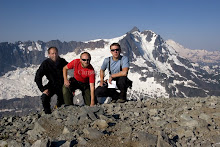
I got off early the other day and decided I would finally scale one of the area mountains that I have wanted to for some time now — Mt. McGinnis. The trail gains nearly 3,500 feet in five miles and was one of the steepest, most difficult hikes I have done (not counting the Inka Trail in Peru). The very tip was clouded over, so I stayed only about 300 feet below the summit to rest and set up for the panoramic shot. I met my friend and coworker, Dan, at the top and we took in the stunning vantage point. All of my muscles ached for at least a few days.
From left to right: A view up the Mendenhall Glacier from the back side of McGinnis; center, the terminus of the glacier flows into Mendenhall Lake and points toward the valley, where most of the 31, 000 residents of Juneau live; to the right in the distance is Douglas Island and Auke Bay.

This is a view from the Mendenhall Valley, where we live. On most days, we can see part of the mountain, and rarely is the summit clear of clouds.
— Christopher


No comments:
Post a Comment